█50° vertical field of view; scanning radius 70m; Dual echo mode outputs 960,000 dots per second
Number of lines: 48 lines
Horizontal field of view: 360°
Vertical field of view: 50° (-5°~ +45°)
Ranging capacity: 0.1~70m(40m@10%)
Ranging accuracy:2cm(1σ)
Scan rate: 10Hz
Communication interface: 100 Gigabit Ethernet 100BASE-TX
Laser wavelength: 905nm
Protection level: IP67 & IP6K9
█Performance Parameter

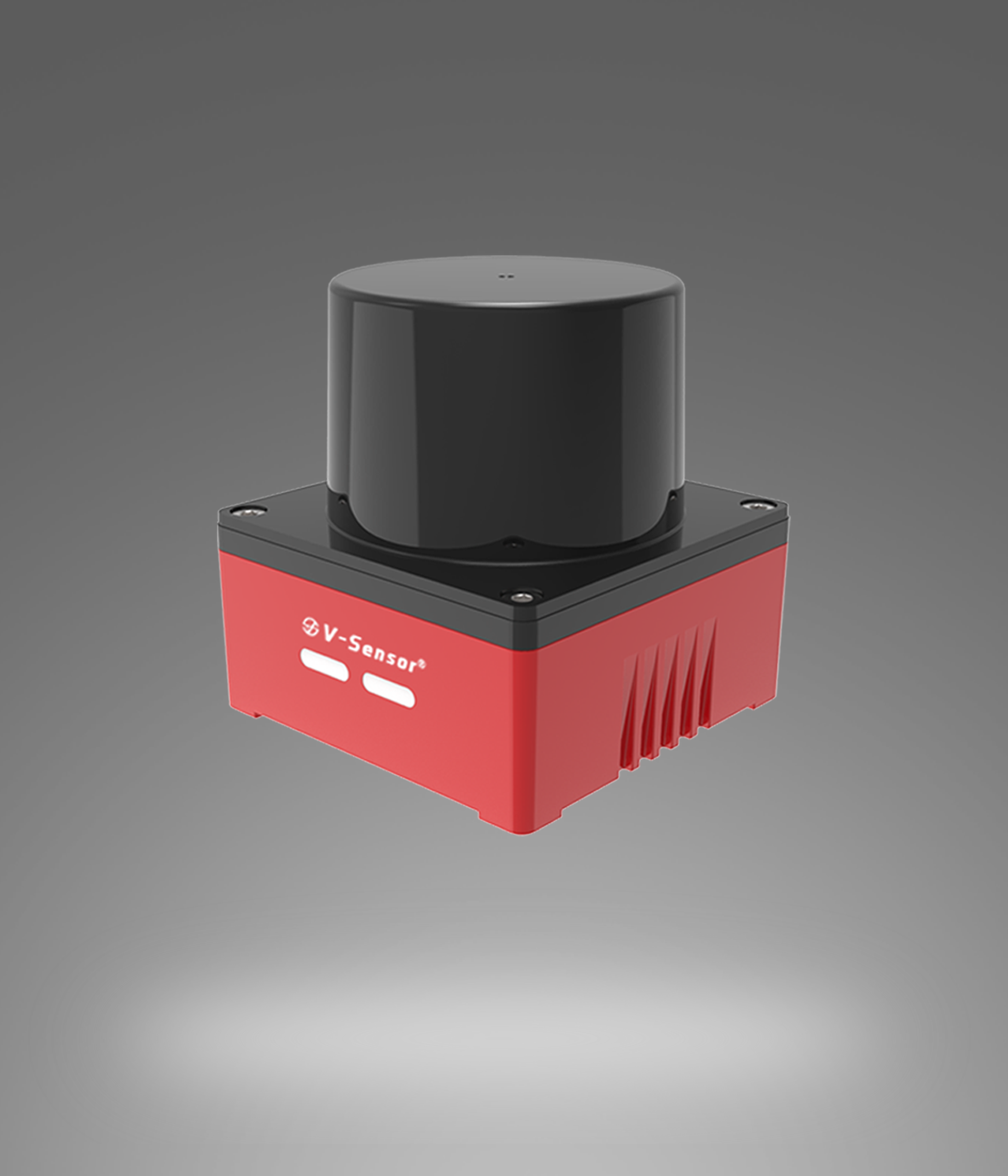
█OW1-360---48-line 3D 360° laser scanning radar
Industrial-grade environmental awareness lidar
Laser scanning and ranging of targets within a horizontal 360° and vertical 50° field of view
48 lines, 10Hz scan rate, 2cm (1σ) ranging accuracy
It can cover a radius of up to 80m and a large area of 20,000 square meters
Strong anti-interference ability, IP67&IP6K9K protection
◆OW1 is a high-line-count 3D LiDAR that uses time-of-flight (TOF) to achieve distance measurement by emitting light pulses and receiving diffuse reflected light.
OW1 takes the center of the base as the coordinate origin, uses three-dimensional coordinates to characterize the surrounding environment, and can output information such as the distance, angle, and reflectivity of the target.
OW1 has a horizontal field of view of 360° and a vertical field of view of 50° (-5°~+45°), which can scan and distance a wide range of targets, generate 3D point clouds, and achieve fast and accurate perception of the surrounding environment.
OW1 is suitable for robots, logistics and distribution, intelligent warehousing AGVs, UAV surveying and mapping and many other fields, meeting the intelligent needs of environmental perception, navigation and positioning in different scenarios.
▁▁▁▁▁▁▁▁▁▁▁▁▁▁▁▁▁▁▁▁▁▁▁▁▁▁▁▁▁▁▁▁▁▁▁▁▁▁▁▁▁▁▁▁▁▁▁▁▁▁▁▁▁▁
█Reasons for customer selection
This 360°48-line 3D LiDAR is compact (64.6 (H)×55.2 (φ) mm), lightweight (220g±20g), and provides 3 M3 screw holes and 2 locating holes as typical mounting interfaces for easy installation and fixing. It can cover a radius of up to 80m, generate 3D point clouds with angle and depth information, achieve fast and accurate perception of the surrounding environment, and meet the intelligent needs of environmental perception, navigation and positioning in many fields such as robots, logistics and distribution, intelligent warehousing AGVs, and UAV surveying and mapping.
▁▁▁▁▁▁▁▁▁▁▁▁▁▁▁▁▁▁▁▁▁▁▁▁▁▁▁▁▁▁▁▁▁▁▁▁▁▁▁▁▁▁▁▁▁▁▁▁▁▁▁▁▁▁
█Advantages and features
The ranging ability can reach 0.1~70m (40m@10%), and the ranging accuracy is 2cm (1σ), which can accurately sense the target distance.
OW1 can laser scan and distance targets within a 360° horizontal and 50° vertical field of view
Using an 8pin aviation plug as the electrical interface, the connection is stable and reliable, meeting the needs of industrial-grade use
Operating temperature range - 20~60°C, storage temperature - 40~85°C, adapting to a wide range of ambient temperature conditions
The protection level reaches IP67&IP6K9K, which has good dust and water resistance.
It supports GPS and PTP time synchronization for high-precision time calibration.
▁▁▁▁▁▁▁▁▁▁▁▁▁▁▁▁▁▁▁▁▁▁▁▁▁▁▁▁▁▁▁▁▁▁▁▁▁▁▁▁▁▁▁▁▁▁▁▁▁▁▁▁▁▁
█Applications
Lawn mower robot | AMR, Forklift,|Industrial Automation,|UAV Mapping


Business Manager: Manager Jiang
Tel:13391208082
E-mail:13391208082@163.com

Business Manager: Manager Li
Tel:18737118612
E-mail:18737118612@163.com

Business Manager: Manager Lv
Tel:15238312802
E-mail:15238312802@163.com

Business Manager: Manager Wang
Tel:15238360758
E-mail:15238360758@163.com

Copyright © 2024 Siman Sensor Technology Co., Ltd. 豫ICP备2024098333号